
The Inside on the Outside
The Big Picture
Three separate storylines, one map. In the remote northwest Hawaiian Islands, Hurricane Lala is bearing down on a protected marine monument with no year-round residents — but real research stations, seabird colonies, and monk seal habitat in its path. In the Mid-Atlantic, a slow-moving front is wringing out another round of heavy rain over ground that includes the New York City metro, with flash-flood probabilities forecasters call “firmly” above 50 percent. And across the South and Southern Plains, a heat dome that simply will not move keeps rewriting overnight-low records — and per the latest extended outlook, it’s not going anywhere through next week.

Lead Story: Hurricane Lala & the Marine Monument
Hurricane Warning for a Place With No Year-Round Residents HURRICANE CONDITIONS EXPECTED
Lala is a hurricane again — 100 mph winds as of the latest advisory, centered roughly 140 miles southwest of Maro Reef and closing in on the Papahānaumokuākea Marine National Monument, the vast protected reef-and-atoll system northwest of the main Hawaiian Islands. A Hurricane Warning covers the monument from Lisianski Island to Maro Reef; a Tropical Storm Warning extends east to French Frigate Shoals. Nobody lives here year-round, but the monument hosts researchers, one of the world’s largest seabird colonies, and critical monk seal habitat — all of it now in the path of hurricane-force wind and large, inundating surf. The storm is forecast to weaken gradually over the next couple of days but remain a hurricane through the weekend, then do something less common: forecasters expect it to restrengthen once it clears the monument and moves back over open, warmer water by midweek.
Trouble Spots
Mid-Atlantic Flash Flood Risk — Day 1 SLIGHT RISK 2/4
A cold front stalling through the Piedmont and eastern Pennsylvania is the trigger: forecasters expect a line of storms to fire along and east of it this afternoon, with the heaviest footprint aimed at a corridor from Trenton through the New York City metro, northern New Jersey, and western Long Island. The latest high-resolution model guidance puts better than 50-to-80 percent odds on 3+ inches somewhere in that corridor — numbers forecasters describe as having climbed “firmly” over the past several cycles. A second slight-risk day follows Friday for Virginia into the Carolinas, and a broader but lower-end marginal risk stretches up the East Coast and separately across the West through the weekend.
Central Plains Severe Weather SLIGHT RISK 2/4
Today’s severe threat splits two ways: large hail and isolated damaging gusts from the Mid-Atlantic into the Central Appalachians, where a low-probability tornado risk also exists across the Delmarva into central New Jersey; and a separate corridor from Nebraska into northwest Wisconsin, where very large hail (over 2 inches) and severe gusts are possible as a cold front interacts with a plume of rich low-level moisture. Friday shifts the hail threat to Nebraska and northern Kansas, plus a second severe risk for the Carolinas and Georgia.
Heat Dome — No Exit in Sight EXTREME HEAT WARNINGS
The Southern Plains and Lower Mississippi Valley are locked under a strong, persistent upper-level high that forecasters now say will hold through all of next week. Overnight lows stuck in the low 80s mean little real recovery between days of 100-plus heat — the kind of stacked, multi-day exposure that raises the risk of heat illness even for people used to summer heat. Extreme Heat Warnings remain up for the Desert Southwest and the southern Plains into the Deep South; Heat Advisories cover Florida and the Southeast coast.
Fire Weather — Pacific Northwest & Great Basin ELEVATED FRIDAY
No critical fire weather areas today — a genuinely quiet national map. That changes Friday: a Pacific storm system nearing the Oregon/Washington coast brings a chance of isolated dry lightning along and east of the Cascades, while gusty, dry southwesterly winds and humidity as low as 10–15 percent raise elevated fire concerns from northeastern California into northern Nevada and southern Oregon, where fuels are already drought-stressed.
The Tropics — Three Basins
Atlantic — Quiet NOTHING EXPECTED, 7 DAYS
No tropical cyclone formation is expected anywhere in the Atlantic, Caribbean, or Gulf over the next week. In mid-to-late August, that silence is itself the story — this basin is normally waking up right now.
East Pacific — Two Systems to Watch LOW CONFIDENCE, EARLY
A tropical wave a few hundred miles south of southern Mexico has a low (20 percent) chance of development in the next 48 hours but a high (80 percent) chance over 7 days, as it tracks generally west-northwest well offshore. A separate, broader low well south of Baja California is a longer shot — 10 percent in 48 hours, 30 percent over 7 days.

Central Pacific — Lala, and a Likely Follow-Up HIGH CONFIDENCE, NEW SYSTEM
Beyond Hurricane Lala (see Lead Story), forecasters are watching a second area of low pressure well east-southeast of the Hawaiian Islands that’s becoming better organized. They put high odds — 90 percent in 48 hours, 90 percent over 7 days — on a tropical depression forming later today or tonight as it tracks west to west-northwest toward the islands. Interests in Hawaii should keep an eye on this one right behind Lala.

The Inside what the discussions actually say
“Firmly” is doing a lot of work in today’s flood forecast. WPC’s discussion says probabilities for the NYC-metro corridor are now “firmly greater than 50 percent (60–80 percent)” — language forecasters reach for only when confidence has genuinely built across several model cycles, not just one run. In the same breath, they admit the exact question of “where does the line initiate?” isn’t resolved. That’s the honest version of a flood forecast: high confidence a corridor gets hit, real uncertainty about which few miles inside it get the worst of it.
Lala is forecast to weaken, then come back. Hurricanes over cool or disrupted water typically just fade. Lala’s track takes her near — and partly over — the shallow reef structure of the monument, which can disrupt a storm’s inner core, before she moves back onto open, warmer Pacific water by midweek. Forecasters are calling for exactly that arc: gradual weakening now, followed by restrengthening once she’s clear. It’s a reminder that “weakening” in an advisory isn’t always the end of the story.
Two systems, two very different confidence numbers, same basin. The Central Pacific’s new disturbance carries 90 percent odds of becoming a depression within 48 hours. The East Pacific system near Mexico carries just 20 percent over the same window. Same forecasters, same tools, wildly different confidence — because one system is already organizing into a coherent circulation and the other is still just a moisture blob with favorable conditions around it. The percentage is a read on organization, not just on ingredients.
The sun had its biggest outburst of the day mid-morning. Space weather forecasters logged an M8.1 flare — the strongest of three M-class flares in 24 hours — with a radio signature indicating a fast eruption of solar material behind it. The practical effect for most people: essentially none. But it’s part of why the geomagnetic field is expected to reach “active” levels the next two days, well short of a storm, but enough that we’re watching for it in Also Watching below.
Looking Ahead
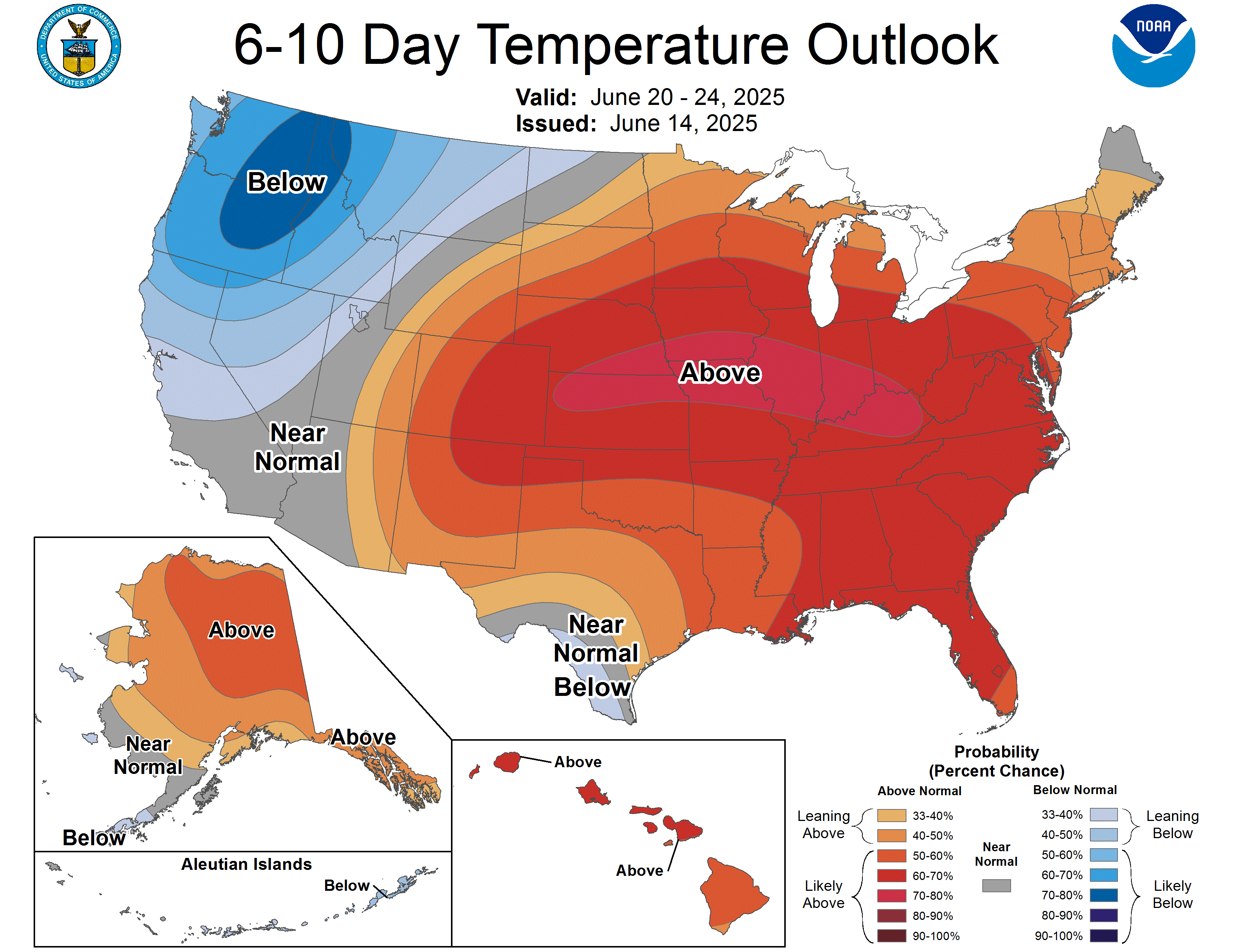
CPC’s 6-to-10 day outlook (Aug 25–29) keeps an amplified ridge anchored over the Great Plains, meaning above-normal temperatures are favored for most of the West and, with better than 80 percent odds, the Southwest and Southern Plains — the heat dome isn’t just persisting, it’s expanding its footprint. The Northeast sits closer to normal under a weak trough, with a slight lean toward wetter than normal along the Eastern Seaboard from the Carolinas to New England. Above-normal precipitation is also favored across a wide swath of Alaska and, notably, Hawaii — no help for Lala’s forecast track, but consistent with an active tropical pattern there.
Also Watching
- Space Weather: Following this morning’s M8.1 solar flare, the geomagnetic field is expected to reach “active” levels through Friday as a coronal hole high-speed stream’s influence lingers — a notch below the minor-storm (G1) threshold that typically brings aurora into the northern-tier states, but worth a glance north after dark if you’re already at high latitude.
- Fire Weather: Covered above in Trouble Spots — elevated conditions build across the Pacific Northwest and northern Great Basin starting Friday.
- Marine — North Atlantic: The Ocean Prediction Center has two separate Gale Warnings active across the North Atlantic shipping lanes tonight, plus dense fog in several zones — routine for late August, but worth knowing if you’ve got mariners in the family.
- Drought Monitor (featured this Thursday): This week’s map — valid Tuesday, released today — tells two opposite stories. Widespread heavy rain from Nebraska through Iowa, Illinois, Indiana, and Ohio (over a foot in parts of eastern Indiana) erased abnormally dry conditions across a wide swath of the Midwest, and Hawaii saw similar relief as Lala’s rain wiped out most of the islands’ dry areas. But the same ridge behind today’s Heat Dome story is doing double duty as a drought engine: flash-drought conditions have left ponds and creeks dry and crops struggling across Texas, Louisiana, Arkansas, and Oklahoma, where extreme-to-exceptional drought holds over the Texas Panhandle, western Oklahoma, and southeastern Arkansas. The High Plains and West aren’t much better — exceptional drought, the worst category on the map, persists in parts of Nebraska, Colorado, Utah, Idaho, and Oregon. In Puerto Rico, a deepening drought has pushed streamflow to record lows and triggered active water-service restrictions for some residents. Looking ahead, the same East Coast rain we’re tracking in today’s flood risk should bring above-normal precipitation to the Northeast and Mid-Atlantic over the next two weeks — good news for that region’s drought picture — while the South stays locked in the dry pattern.

Look Up Tonight
FIRST QUARTER · ~58% LIT
This Evening: The Moon reaches First Quarter today, appearing as a crisp half-disc high in the southern sky at dusk, in Scorpius. It’s the best-placed the Moon gets all lunar cycle for casual viewing — up in the evening, gone by midnight, no need to wait for a pre-dawn alarm.
Overnight & Pre-Dawn: Nothing marquee active tonight — a quiet stretch between meteor showers. Worth a glance regardless: Jupiter rises in the east a few hours before dawn, easily the brightest point of light in that part of the sky.
Cloud Check: Clearest skies tonight sit across the West and Northern Plains, behind today’s active weather. The Mid-Atlantic and Northeast are the areas to expect the most cloud and storm interference given the flood-risk setup covered above; the monsoon-fed Southwest keeps its usual afternoon-into-evening cloud buildup.
Circle the Date: Mark August 28 — the full Sturgeon Moon coincides with a partial lunar eclipse deep enough to produce a Blood Moon, visible across all of North and South America.
One Cool Thing
Today’s flood forecast for the New York City area hinges on something meteorologists call a “bookend vortex” — a small, self-reinforcing spin at the end of a line of thunderstorms that lets new storms keep forming in the exact same spot instead of moving through and giving the ground a break. It’s called back-building, and it’s the single most common ingredient behind the flash floods that catch entire metro areas off guard: not one big storm, but the same storm, effectively, redrawing itself over and over above the same square mile for hours.
Shareables
Source Ledger every claim, timed & sourced
Our standard: nothing in this briefing older than 8 hours without a flag. Products that update once daily or weekly are used at their most recent issuance and marked. All products below were retrieved via the Drive automation at 13:32 UTC (9:32 AM EDT) today with no fetch failures.
| Product | Issued | Status |
|---|---|---|
| WPC Short-Range Forecast Discussion | 4:00 AM EDT Thu Aug 20 | CURRENT |
| WPC Extended (Day 3–7) Forecast Discussion | 3:36 AM EDT Thu Aug 20 | CURRENT |
| WPC Excessive Rainfall Discussion (Days 1–5) | 3:55 AM EDT Thu Aug 20 | CURRENT |
| SPC Day 1 / Day 2 / Day 3 Convective Outlooks | 7:46 AM / 1:43 AM / 2:30 AM CDT Thu | CURRENT |
| SPC Day 1–2 Fire Weather Outlooks | 12:38 AM / 12:42 AM CDT Thu Aug 20 | CURRENT |
| NHC Atlantic Tropical Weather Outlook | 8:00 AM EDT Thu Aug 20 | CURRENT |
| NHC East Pacific Tropical Weather Outlook | 5:00 AM PDT Thu Aug 20 | CURRENT |
| CPHC Central Pacific Tropical Weather Outlook | 2:00 AM HST Thu Aug 20 | CURRENT |
| Hurricane Lala — Advisory 32 / 32A | 9:00 AM / 2:00 AM HST Thu Aug 20 | CURRENT |
| CPC 6-10 / 8-14 Day Prognostic Discussion | 3:00 PM EDT Wed Aug 19 | CURRENT ISSUANCE · daily product; next ~3 PM today |
| SWPC Space Weather Forecast Discussion | 8:15 AM EDT (1215 UTC) Thu Aug 20 | CURRENT |
| OPC High Seas Forecast (METAREA IV / N. Atlantic) | 6:38 AM EDT (1030 UTC) Thu Aug 20 | CURRENT · used, active Gale Warnings |
| Moon phase & lunar eclipse data (USNO / NASA sourcing hierarchy) | N/A — astronomical calendar data | CURRENT |
| US Drought Monitor national map & narrative | Valid 8 AM EDT Tue Aug 18 (rel. Thu Aug 20) | CURRENT ISSUANCE · weekly product |
For Newsrooms & Reporters
Need a Meteorologist On Air or On the Record Today?
Bob Cox — veteran broadcast meteorologist heard mornings on WTIC NewsTalk 1080 (Hartford) and forensic meteorologist with 30+ years analyzing high-impact weather — tracks these stories in real time and is available for interviews and expert comment: radio, TV, print, podcast, fast turnaround.
Today’s interview-ready angles: Hurricane Lala’s unusual weaken-then-restrengthen forecast and what it means for a warning issued over a place with no permanent population · the “firmly above 50 percent” NYC-metro flash flood setup and what forecaster confidence language actually signals · a heat dome that’s now forecast to persist a full extra week · a second Central Pacific system developing right behind Lala.
BOOKING: kaitlin@coxweatherservices.com · 888-248-9347 · coxweatherservices.com · attribution: “Bob Cox, meteorologist, Cox Weather Services”