
The Inside on the Outside
The Big Picture WPC
Hawaii is doing this twice in eight days. Tropical Storm Moke is closing in on the Big Island today, riding the same saturated ground Hurricane Lala left behind last weekend — a slower, farther-south track than Lala’s, but still a five-to-ten-inch rain threat with life-threatening flooding on the table. On the mainland, a stubborn upper ridge is baking the south-central U.S. and Southwest with record-breaking heat, while its northern edge kicks off severe storms and isolated flash flooding from the northern Rockies through the Great Basin. And just south of Mexico, a new tropical storm is essentially a formality — the Hurricane Center is giving it near-100 percent odds of getting a name within 48 hours.
Lead Story: Moke & Hawaii CPHC/NHC Advisory 12
Tropical Storm Moke — Closing In On the Big Island LIFE-THREATENING FLOODING
Moke is a tropical storm, holding at 45 mph winds and easing back slightly from its Saturday peak, centered about 330 miles southeast of Hilo early this morning and moving west at 12 mph. Its closest pass to the Big Island comes later today — roughly 200 miles south, farther offshore than Lala’s brush last weekend, and no coastal watches or warnings are posted for the islands themselves (only for the offshore waters 40 to 240 miles out). But distance from the center isn’t the number that matters here: the rain shield is. Forecasters expect 5 to 10 inches on the Big Island, with isolated totals to 15 inches on the windward and southeast slopes — ground that’s already saturated and scarred from Lala’s flooding eight days ago, which destroyed or damaged more than 100 homes and is tied to at least one confirmed death. A Flood Watch covers the Big Island through Monday afternoon, and a Wind Advisory (gusts to 55 mph) runs through 6 PM today for Maui, Molokai, Lanai, Kahoolawe and the Big Island. Shear and dry air are already eating into Moke’s convection — see The Inside — and forecasters expect it to keep weakening, possibly down to a remnant low by midweek. Lala, meanwhile, has dropped to 70 mph and is well north of the uninhabited Papahanaumokuakea monument, pulling away with no further threat to the main islands.

Trouble Spots
Dangerous, Record-Breaking Heat — South-Central U.S. into the Southwest MAJOR–EXTREME HEATRISK
A strong, parked upper ridge is holding the southern tier in place: afternoon highs in the upper 90s to 100s, worst over the Southern Plains and Four Corners, with heat indices running 105–115. The dangerous part is overnight — little to no recovery is expected, and forecasters say dozens of daily high and low temperature records are likely to fall through the week. Extreme Heat Warnings and Heat Advisories are already posted across the Four Corners, Southern Plains, and Lower Mississippi Valley. Check on neighbors without reliable air conditioning.
Flooding — Northern Plains to the Ozarks, Southwest & Great Basin, Lee of Lake Erie MARGINAL RISK 1/4
Two separate corridors: a plume of deep moisture (1.5–1.75+ inches precipitable water) is fueling convective development from the Dakotas south toward the lower Missouri Valley and Ozarks, though forecasters admit real disagreement on how far south storms actually organize — see The Inside. Separately, the same monsoonal moisture feeding the Southwest’s daily storms extends the isolated flash-flood risk from the Southwest through the Great Basin and into the central High Plains, and a small, targeted area over northwestern Pennsylvania and far western New York faces lake-enhanced downpours later today.
Severe Storms — Northern Rockies/Plains & Northern Great Basin SLIGHT RISK 2/5
A shortwave trough crossing the northern Rockies this afternoon and evening sets off multicell and transient supercell storms across central/eastern Montana, capable of large hail and damaging gusts — some possibly topping 75 mph as clusters grow upscale over a well-mixed boundary layer. A second, somewhat weaker area of storms fires over the northern Great Basin (mainly northern Utah and vicinity), with a scattered severe-gust threat there too.

The Tropics — Three Basins NHC/CPHC outlooks
Central & East Pacific: Two Storms Near Hawaii, Two More Lining Up Off Mexico
Moke and Lala lead (see above). Off Mexico, EP92 is about as close to a sure thing as this business gets — near 100 percent odds of becoming a tropical storm within 48 hours, with advisories likely starting later today, several hundred miles south-southwest of the Baja Peninsula. A second disturbance, EP91, trails just behind it with a more modest 40 percent chance and may simply get absorbed into EP92 before it can organize on its own. A third area, well southwest of Mexico, isn’t expected to try until midweek.
Atlantic: Three Watch-Areas, None In a Hurry
Nothing active, but three things on the radar: a broad low a few hundred miles southeast of Bermuda with modest (20–30 percent) development odds as it drifts north; a non-tropical low near Portugal with only a slight chance of picking up subtropical traits before unfavorable air ends its chances tonight; and a tropical wave due off the African coast Monday that forecasters give near-zero odds in 48 hours but a real 50 percent by day seven — a system that needs a long runway compared to EP92’s near-instant green light. Why the same setup plays out so differently ocean to ocean: see The Inside.

The Inside what the discussions actually say
The reasoning behind the forecast, pulled from the technical discussions forecasters write for each other.
When forecasters can’t agree, they split the difference — on purpose. WPC’s excessive-rainfall desk was refreshingly candid this morning: their high-resolution model ensembles disagree sharply on how far south the Dakotas’ storm complex tracks before it’s done producing heavy rain. One camp keeps it bottled up over the Dakotas; another drags heavy rain as far south as the Ozarks. Rather than pick a winner, the Marginal Risk they drew stretches to cover both camps’ best guess. That’s not indecision — that’s forecasters admitting the honest range of what the atmosphere might do, and building the map around it instead of a single confident line.
“Well-mixed boundary layer” is forecaster-speak for a downburst machine. SPC’s Montana severe outlook leans on that exact phrase to explain why some wind gusts today could top 75 mph. In plain terms: strong afternoon heating stirs the lower atmosphere into one deep, turbulent layer, so when a thunderstorm’s downdraft slams into the ground, there’s nothing to slow it down on the way — the energy transfers almost straight through. Combine that with steep temperature drop-off with height and you get isolated gusts that punch well above what the storm’s size alone would suggest.
Moke is being unraveled from the inside. The Central Pacific Hurricane Center’s own words: persistent wind shear and dry mid-level air have “eroded much of the convection that was present earlier, leaving the low-level circulation exposed.” That’s a storm losing its engine — the thunderstorms that power a tropical cyclone are being sheared away faster than they can rebuild. It’s why forecasters are comfortable saying Moke could degenerate into a remnant low by Wednesday even while it’s still technically strengthening the rain threat for Hawaii today: the flood danger and the storm’s long-term survival are two different clocks.
Record warmth, top and bottom. WPC’s short-range discussion flags “little to no overnight recovery” as the dangerous part of this heat wave, and the mechanism is the airmass itself: when the air is this loaded with moisture, it absorbs the heat radiating up from the ground overnight and sends a good share of it right back down, rather than letting it escape to space the way it would on a dry night. That’s why forecasters expect record-warm daily lows to fall right alongside the record highs — not cold records, but the warmest overnight minimum ever logged for that date, sometimes called a record max-min. The ground simply never gets a chance to reset before the next afternoon’s heating starts.
Same tropical wave, wildly different odds. The Atlantic’s newest tropical wave — due off Africa Monday — gets near-zero odds of developing within 48 hours but a real 50 percent by day seven. EP92 off Mexico, by contrast, is already at “near 100 percent” in 48 hours. Same basic ingredient — a wave of low pressure — but EP92 is moving into warm water and a favorable upper pattern immediately, while the Atlantic wave has to survive a week of open ocean before its environment turns friendly. Formation odds aren’t really about the wave; they’re about the neighborhood it’s about to move into.
Looking Ahead CPC · current issuance (daily)
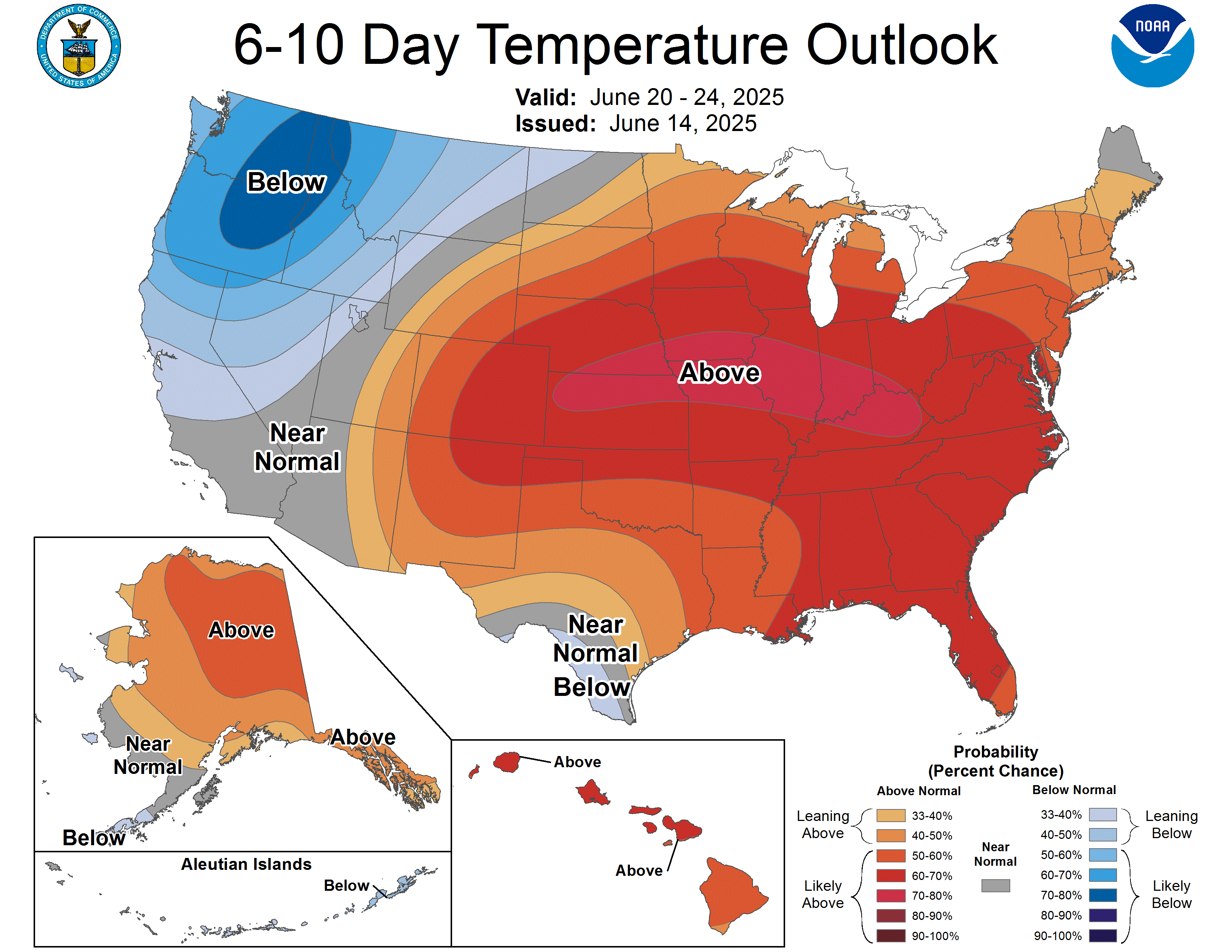
For August 28–September 1: above-normal temperatures favored across most of the CONUS, with very high confidence (better than 80 percent) over the Southwest as the ridge parked there all week peaks in strength mid-period. The Pacific Northwest tilts slightly cool under a nearby trough, and the Great Lakes sit closer to normal. On precipitation, the same Southwest ridge keeps the southern High Plains, southern Rockies, and eastern Great Basin drier than normal, while the Pacific Northwest and the Eastern Seaboard — ahead of an early-period frontal system — lean wetter than normal, with a weaker wet signal near the Red River Valley of the North.
Also Watching
- Space Weather: A quiet stretch — solar activity is low, the only real action a handful of C-flares from a stable sunspot region, and no Earth-directed CMEs detected. The geomagnetic field is expected to stay quiet through Tuesday, so no aurora chances on the near-term forecast. SWPC
- Fire Weather: Two elevated pockets today: isolated dry-lightning ignition risk over the northern Intermountain West and northern Rockies (dry thunderstorms riding over receptive fuels), and elevated conditions across the southern High Plains as a surface low tightens the pressure gradient and drops humidity to 15–20 percent. Monday shifts the same pattern — dry storms over the northern Great Basin, elevated winds/humidity over the Texas South Plains and southwest Oklahoma. SPC Fire Wx
- Drought Monitor: Weekly product; the next national map lands Thursday, August 27 — featured here every Thursday edition.
Look Up Tonight
Waxing gibbous, about 80 percent illuminated — the Moon is ten to eleven days into its cycle and climbing toward Friday’s Full Moon. Worth marking the calendar: that “Sturgeon Moon” arrives with a deep partial lunar eclipse, up to 96 percent of the disk swallowed by Earth’s shadow, close enough to total that it should take on a reddish “Blood Moon” cast. Visible across North and South America late Thursday into Friday morning.
One Cool Thing
Moke is tracking roughly 100 miles farther from Hawaii than Lala did last weekend, and its tropical-storm-force winds only reach about 115 miles from the center — versus Lala’s 185. By the wind field alone, Moke should be the gentler visitor. But rainfall doesn’t follow the wind radius; it follows the moisture plume, and Moke’s is still aimed squarely at the Big Island’s saturated slopes. That’s the gap between how a storm looks on a wind map and how it actually threatens the ground beneath it — and it’s why “farther south” and “less rain” aren’t the same sentence.
Shareables
Source Ledger every claim, timed & sourced
Every forecast in this issue traces back to a named NWS/NOAA product below. Status shows how fresh each source was at publication.
| Product | Issued | Status |
|---|---|---|
| WPC Short-Range Forecast Discussion | 2:54 AM EDT Sun Aug 23 | CURRENT |
| WPC Extended (Day 3–7) Forecast Discussion | 3:18 AM EDT Sun Aug 23 | CURRENT |
| WPC Excessive Rainfall Discussion | 4:23 AM EDT Sun Aug 23 | CURRENT |
| SPC Day 1 Convective Outlook | 8:52 AM EDT Sun Aug 23 | CURRENT |
| SPC Day 2 / Day 3 Convective Outlooks | 1:51 AM / 3:28 AM EDT Sun Aug 23 | CURRENT |
| SPC Day 1–2 Fire Weather Outlooks | 2:56 AM / 2:58 AM EDT Sun Aug 23 | CURRENT |
| NHC Atlantic Tropical Weather Outlook | 8:00 AM EDT Sun Aug 23 | CURRENT |
| NHC East Pacific Tropical Weather Outlook | 8:00 AM EDT Sun Aug 23 | CURRENT |
| CPHC Central Pacific Tropical Weather Outlook | 8:00 AM EDT Sun Aug 23 | CURRENT |
| CPHC/NHC Tropical Storm Moke Advisory No. 12 | 5:00 AM EDT (11 PM HST) Sun Aug 23 | CURRENT |
| CPHC/NHC Tropical Storm Lala Advisory No. 44 | 5:00 AM EDT (11 PM HST) Sun Aug 23 | CURRENT |
| CPC 6-10 / 8-14 Day Prognostic Discussion | 3:00 PM EDT Sat Aug 22 | CURRENT ISSUANCE · daily product; next ~3–4 PM today |
| SWPC Space Weather Forecast Discussion | 8:30 AM EDT Sun Aug 23 (1230 UTC) | CURRENT |
| US Drought Monitor National Summary | Data through Aug 18, released Thu Aug 20 | CURRENT ISSUANCE · weekly product; next Thu Aug 27 |
For Newsrooms & Reporters
Need a Meteorologist On Air or On the Record Today?
Bob Cox — veteran broadcast meteorologist heard mornings on WTIC NewsTalk 1080 (Hartford) and forensic meteorologist with 30+ years analyzing high-impact weather — tracks these stories in real time and is available for interviews and expert comment: radio, TV, print, podcast, fast turnaround.
Today’s interview-ready angles: Tropical Storm Moke’s Hawaii threat and why “farther south” doesn’t mean “less rain” so soon after Lala’s deadly flooding · the record-breaking Southwest heat wave and why overnight lows are the real danger · EP92’s near-certain formation off Mexico · the northern Rockies/Plains severe wind and hail risk.
BOOKING: kaitlin@coxweatherservices.com · 888-248-9347 · coxweatherservices.com · attribution: “Bob Cox, meteorologist, Cox Weather Services”