
The Inside on the Outside
The Big Picture WPC
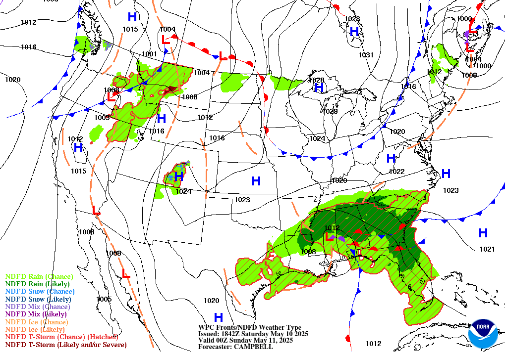
Utah’s desert washes are the flashpoint again today — a Moderate Risk for excessive rainfall and flash flooding holds over the Four Corners for a second straight day, as dual shortwaves and near-record moisture wring repeat rounds of thunderstorms over slot canyons and burn scars already saturated from the weekend. It’s not the only story with teeth: a broad area of low pressure over the northern Gulf is on a fast track toward tropical depression or storm status and a possible Tuesday landfall near the Texas–Louisiana line, dangerous heat holds its ground from the central Plains to the Southeast through the week, and 1,000 miles out in the East Pacific, Karina has grown into a major Category 4 hurricane that will never touch land but is already sending swells toward Baja and Southern California. Closer to the Northeast, watch for a slide toward slight-risk severe weather Tuesday into Wednesday.
Lead Story WPC
Utah’s Wash Country Braces for Round Two MODERATE RISK 3/4
WPC has held a Moderate Risk for excessive rainfall over Utah and the Four Corners for a second day, and the ingredients haven’t eased up. Two shortwaves — one out of Mexico, one out of California — are lifting north together, adding fresh lift to a region already sitting under a strengthening jet streak’s right-rear quadrant. Underneath that lift: precipitable water above 1 inch as far north as the Utah Swell, with anomalies two standard deviations above normal pooled across Arizona, Utah, and western Colorado. Morning storms should be slow to fire while lingering cool air (CINH) works against them, but once instability rebuilds to 500–1,000 J/kg, expect widespread convection with a 20–30 percent chance of hourly rain rates above an inch. Storms will be relatively slow-moving — 15–20 knots over Utah and Colorado, even slower over southern Arizona — while 30–40 knots of shear keeps them organized and repeating over the same corridors. That combination is what turns a normal monsoon afternoon into a flash-flood day: dry washes, slot canyons, and burn scars are the places to watch.
Storm Reports Recap SPC · previous 24 hours
SPC’s preliminary storm log for the 24 hours ending 6:00 AM EDT today shows no tornado reports nationwide, but a very active wind day across the northern High Plains and the Dakotas: 70 separate wind reports stretching from Montana to South Dakota to North Dakota as thunderstorm outflow raced ahead of a strengthening cold front Sunday afternoon and evening. The headline number is a measured 100 mph gust near Buffalo, South Dakota — Category 2 hurricane strength — logged in the same town as reports of downed trees, missing shingles, and building damage. One hail report rounds out the log: a quarter-size stone (1.00 inch) near Big Water, Utah. As always, these are unsurveyed preliminary reports, not a final tally — NCEI’s official Storm Data record, issued weeks to months from now, is the eventual word.

Trouble Spots
Northern Gulf Watches a Fast-Track System SLIGHT RISK 2/4
An area of low pressure over the northern Gulf of America, more than 100 miles south of the Louisiana coast, carries a high 70 percent chance of forming a short-lived tropical depression or storm both through 48 hours and through 7 days — and it’s expected to reach the Upper Texas or southwestern Louisiana coast as soon as tonight or Tuesday morning, watches or warnings possible later today. An Air Force Reserve reconnaissance flight was investigating the system this morning. WPC keeps a Slight Risk of excessive rainfall on the upper Texas coast and far southwestern Louisiana Tuesday into Wednesday, with precipitable water above 2.25 inches capable of several inches of rain regardless of whether the system ever earns a name. Separately, the remnants of Tropical Storm Dolly — now a bare surface trough — continue tossing showers and storms from Hispaniola to the northern Leeward Islands; strong upper winds should suppress redevelopment for a day or two, though conditions turn more conducive again by midweek near the southern Bahamas or Florida Straits.
A Northeast Severe Threat Builds for Tuesday SLIGHT RISK 2/5
SPC’s Day 2 outlook posts a Slight Risk for central New York into central and eastern Pennsylvania and New Jersey Tuesday, with isolated severe storms possible as far west as Nebraska. A negatively tilted upper trough — the sharper, faster-deepening kind — amplifies over the Interior West while multiple mid-level impulses ride the northern edge of a central-U.S. ridge into the Northeast. Forecast soundings show 40-plus knots of effective bulk shear and curved, sizeable low-level hodographs, raising the odds of a couple of supercells with hail, damaging wind, and an isolated tornado threat as storms consolidate into a forward-charging overnight cluster toward the Mid-Atlantic coast. Today itself carries a lower-end Marginal Risk from the central High Plains to the Great Lakes and the lower Colorado River Valley/Great Basin, mainly this afternoon into tonight.
The Heat Wave Isn’t Done MAJOR TO EXTREME HEATRISK
Dangerous heat persists across the central and southern Plains, Midwest, Mid-Atlantic, and Southeast through Friday, with highs in the 90s to low 100s and warm overnight lows in the 70s to near 80 keeping the heat compounding after dark rather than breaking. WPC flags widespread Major to Extreme HeatRisk across the corridor. Check on neighbors without reliable air conditioning, especially overnight — the missing overnight cooldown is often the more dangerous half of a heat wave. Relief arrives Friday into the weekend for the Ohio Valley and Mid-Atlantic as a cold front presses south, but the core of the heat holds on across the central/southern Plains and lower Mississippi Valley as the ridge retrogrades and rebuilds into next week.
The Tropics Three Basins
Atlantic 2 SYSTEMS WATCHED
An area of low pressure over the northern Gulf of America (AL97) — see Trouble Spots above — carries a high 70 percent chance of short-lived tropical depression or storm formation, both through 48 hours and 7 days, on track for the Upper Texas or southwestern Louisiana coast tonight or Tuesday. Separately, the remnants of Tropical Storm Dolly, now a surface trough, continue producing showers and storms from Hispaniola to the northern Leeward Islands; formation chances stay low (near 0 percent through 48 hours, 20 percent through 7 days) while strong upper winds hold it down, though the southern Bahamas or Florida Straits environment turns more conducive again by midweek.

East Pacific HURRICANE KARINA · CAT 4
Hurricane Karina intensified into a major Category 4 overnight — 145 mph winds, 942 mb central pressure — and additional strengthening is possible today before fluctuations set in through midweek. The storm poses no direct threat to land: it’s tracking west roughly 1,000 miles southwest of the tip of Baja California, and NHC’s advisory carries no coastal watches or warnings. The one impact reaching shore is indirect — swells already affecting southwest Mexico and the Baja Peninsula are likely to spread north to Southern California Monday through midweek, raising the risk of life-threatening surf and rip currents even with the storm nowhere close. Separately, well offshore of southwestern Mexico, disturbance EP95 carries a high 90 percent formation chance through 7 days and should become a tropical depression within a couple of days as it tracks northwest; see The Inside for why forecasters are hedging on where it goes from there.

Central Pacific TROPICAL STORM LOWELL
Tropical Storm Lowell has strengthened slightly to 60 mph and could reach hurricane strength by Monday night or Tuesday as it tracks west roughly 855 miles east-southeast of the Big Island. No coastal watches or warnings are in effect, and the forecast track keeps Lowell’s core well clear of the main Hawaiian Islands. A separate area of low pressure could try to organize south or southwest of Hawaii in a couple of days — a low, 30 percent chance through 7 days for now.

The Inside decoded, today
“Moderate Risk,” translated. WPC’s Moderate Risk for excessive rainfall — level 3 of 4 — means numerous flash flooding events are likely, with the potential for smaller streams and even larger rivers to respond, and flooding that can include debris flows in or near burn scars. That last phrase is doing real work in today’s Utah setup: it’s not the total rainfall that’s dangerous so much as where it falls. A slot canyon or dry wash that’s carried nothing but sand for months can go from empty to deadly in minutes when repeat rounds of storms train over the same terrain — which is exactly what today’s “aligned propagation vectors” (forecaster-speak for storms moving one after another along the same line, like train cars on a track) are set up to do.
A trough by any other tilt. SPC’s Day 2 outlook describes a negatively tilted upper trough amplifying over the Interior West tomorrow — the sharper, faster-deepening orientation that runs northwest-to-southeast, as opposed to a positively tilted trough (southwest-to-northeast), the steadier, more common setup that acts as a longer-duration moisture pump. A negative tilt means energy digs and ejects quickly; it’s the difference between a system that lingers for days and one that fires a round of strong-to-severe storms across New York, Pennsylvania, and New Jersey Tuesday and is largely through the region by Wednesday morning.
The forecast that hedges on purpose. WPC’s extended discussion does something worth noticing: it tells you which model it’s ignoring, and why. Most guidance — including the AI-driven EC-AIFS and AI-GFS — tracks the Pacific disturbance known as Invest 95E out to sea well west of California. But the latest 18Z and 00Z GFS runs would carry it north, close enough to directly affect Southern California. WPC’s forecasters wrote plainly that they “currently do not favor” that outcome and built their rainfall forecast around the majority view — while saying so out loud rather than quietly picking a side. That’s the discipline this newsletter exists to translate: a forecast isn’t a guess dressed up as certainty, it’s a bet the forecasters are willing to explain.
A Cat 4 that will never make landfall. Karina is now a major hurricane — 145 mph, a Category 4 — and will almost certainly never come within a thousand miles of anyone. That’s not a contradiction; open-ocean hurricanes intensify more freely than ones brushing land or fighting shear, and Karina has had nothing but warm water and calm upper winds in its way. The only fingerprint it will leave on the U.S. is indirect: swells generated a thousand miles offshore, arriving on Southern California beaches as dangerous surf and rip currents by midweek, with nobody within sight of the storm itself. A hurricane’s category describes the storm, not the threat to any particular coastline.
Reading the wind report, not just the number. A single line in yesterday’s storm log reads “1 N Buffalo, Harding, SD” next to a wind speed of 100 — a measured, Category 2 hurricane-force gust, logged alongside a separate report of tree damage and blown-off shingles in the same town at the same minute. Two things about that: it’s a real instrument reading, unlike reports marked “UNK,” where the speed wasn’t actually measured — and it’s still preliminary. This newsletter never assigns EF-ratings or “confirmed” language beyond what the raw report says, because that’s NCEI’s job, done over the weeks and months after the fact, not ours today.
Looking Ahead CPC · current issuance
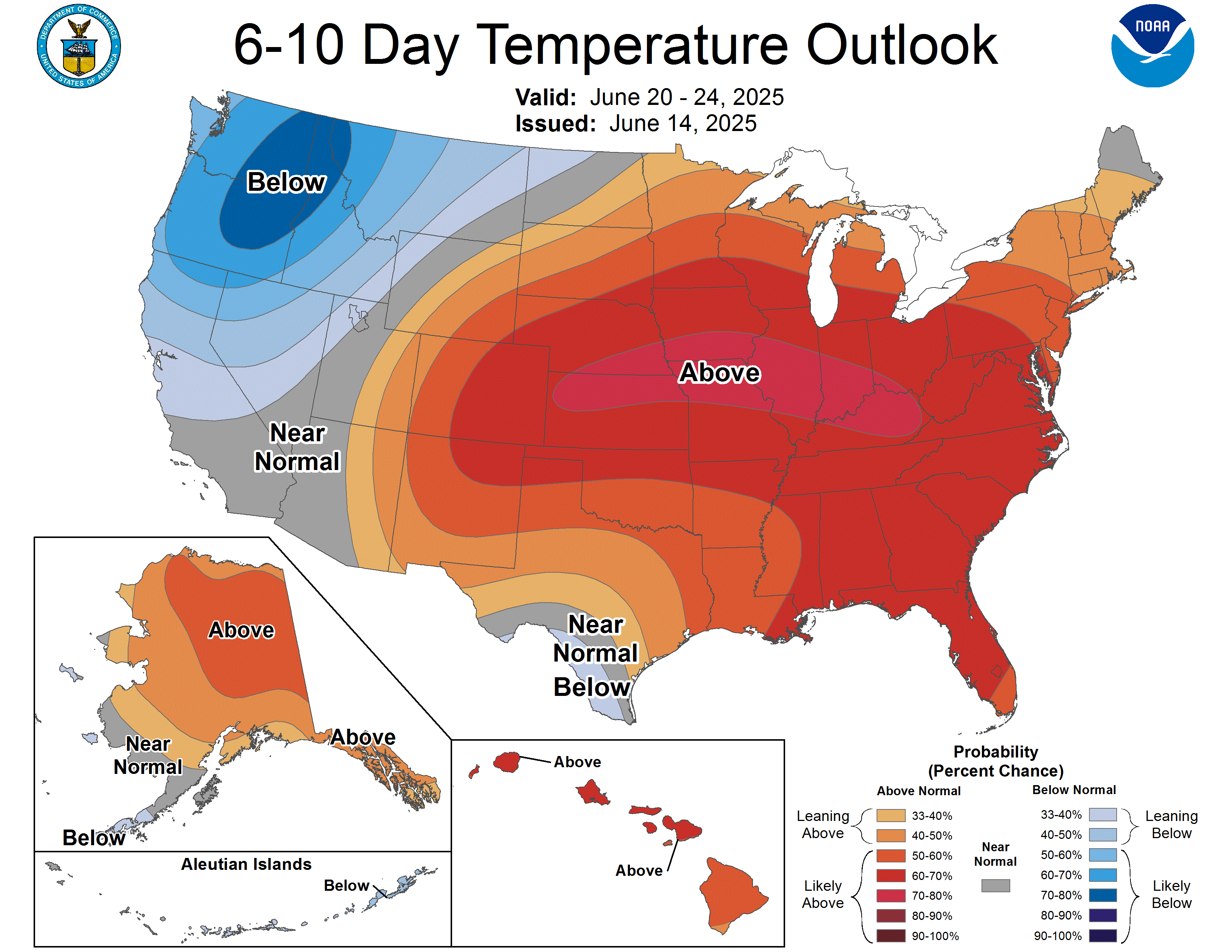
CPC’s outlook keeps the ridge in charge: above-normal temperatures are favored across nearly the entire country east of the Rockies for both the September 5–9 and September 7–13 windows, with the highest-confidence signal — better than 80 percent — centered on the Central and Southern Plains. Connecticut sits on the warm side for both periods, trending toward near-normal to slightly below-normal precipitation. The Pacific Northwest and adjacent northern California buck the trend, running cool under a lingering trough, and CPC explicitly ties the above-normal Hawaii temperatures and the elevated southwestern-U.S. moisture signal to “the current El Niño.” Confidence: 3 of 5 for the 6–10 day window, dropping to just 1 of 5 for 8–14 days — CPC’s own forecasters cite “very weak height anomalies” as the reason the pattern gets harder to pin down that far out.
Also Watching
- Aurora Watch: Active geomagnetic conditions from a positive-polarity coronal hole stream are winding down — SWPC calls for lingering active levels early today before quieting to mostly quiet conditions Tuesday and Wednesday. Solar wind speeds have run 390–475 km/s with the field’s Bz dipping to -11 nT, enough for elevated but not guaranteed aurora chances at high latitudes overnight. A filament eruption in the Sun’s northeast quadrant is also being watched for a possible Earth-directed component. SWPC
- Fire Weather: A genuinely modest fire day both today and Tuesday — a weak surface trough over the Northwest into northwestern Nevada brings 15–20 mph downslope winds and afternoon relative humidity down to 15–20 percent over already-dry fuels: elevated, not critical, conditions across a fairly narrow corridor. SPC Fire Wx
- Drought Monitor: Weekly product; next national map Thursday, September 3 — featured here every Thursday edition.

Look Up Tonight
One Cool Thing
That 100 mph gust logged in rural South Dakota yesterday — Category 2 hurricane force — came out of a day SPC only rated a “Marginal Risk,” the lowest category on its five-level scale. It’s a good reminder that severe-weather categories describe how likely and how widespread a risk is, not a ceiling on how strong any single storm can get; a Marginal Risk day can still put an isolated cell’s outflow on par with a landfalling hurricane.
Shareables
For Newsrooms & Reporters
Need a Meteorologist On Air or On the Record Today?
Bob Cox — veteran broadcast meteorologist heard mornings on WTIC NewsTalk 1080 (Hartford) and forensic meteorologist with 30+ years analyzing high-impact weather — tracks these stories in real time and is available for interviews and expert comment: radio, TV, print, podcast, fast turnaround.
Today’s interview-ready angles: Utah’s slot-canyon and burn-scar flash flood risk and what “Moderate Risk” actually means · the Gulf system’s fast track toward the Texas–Louisiana coast · Hurricane Karina’s Category 4 status and the swell threat reaching California without a landfall · Tuesday’s building Northeast severe weather setup.
BOOKING: kaitlin@coxweatherservices.com · 888-248-9347 · coxweatherservices.com · attribution: “Bob Cox, meteorologist, Cox Weather Services”
Source Ledger every claim, timed & sourced
Our standard: nothing in this briefing older than 8 hours without a flag. Products that update once daily or weekly are used at their most recent issuance and marked.
| Product | Issued | Status |
|---|---|---|
| WPC Short-Range Forecast Discussion | 2:59 AM EDT Mon Aug 31 | CURRENT |
| WPC Extended (Day 3–7) Forecast Discussion | 3:10 AM EDT Mon Aug 31 | CURRENT |
| WPC Excessive Rainfall Discussion (Days 1–5) | 4:27 AM EDT Mon Aug 31 | CURRENT |
| SPC Day 1 / Day 2 / Day 3 Convective Outlooks | 2:01 / 2:04 / 3:16 AM EDT Mon | CURRENT |
| SPC Day 1–2 Fire Weather Outlooks | 1:03 / 1:05 AM EDT Mon Aug 31 | CURRENT |
| SPC Storm Reports D-1 / D-2 (dated Aug 30 / Aug 29) | fetched 4:13 AM EDT Mon Aug 31 | CURRENT |
| NHC Atlantic Tropical Weather Outlook | 2:00 AM EDT Mon Aug 31 | CURRENT |
| NHC East Pacific Tropical Weather Outlook | 2:00 AM EDT Mon Aug 31 | CURRENT |
| CPHC Central Pacific Tropical Weather Outlook | 2:00 AM EDT Mon Aug 31 | CURRENT |
| NHC Hurricane Karina Advisory No. 16 | 5:00 AM EDT Mon Aug 31 | CURRENT |
| NHC/CPHC Tropical Storm Lowell Advisory No. 15 | 5:00 AM EDT Mon Aug 31 | CURRENT |
| CPC 6-10 / 8-14 Day Prognostic Discussion | 3:00 PM EDT Sun Aug 30 | CURRENT ISSUANCE · daily product; next ~3 PM today |
| SWPC Space Weather Forecast Discussion | 8:30 PM EDT Sun Aug 30 (0030 UTC) | CURRENT |
| OPC High Seas Forecast (N Atlantic) | 6:30 AM EDT Mon Aug 31 | CURRENT |
| US Drought Monitor National Summary | valid Aug 25 (released Aug 27) | CURRENT ISSUANCE · weekly product; next Thu Sep 3 |